• About Us (EN/JP)
    • About Us
    • 私たちについて
    • Our Managing Director
  • News
    • Mr. Thomas Lee Presents at EEHB 2024
    • Paper Published on HKIE Transactions
    • 無人機協助搜索失蹤人士
    • 土地測量師測量繪地圖30年 用專業知識助搜索行山失蹤者【附行山11個注意事項】
    • TVB創科導航 無人機睇風水
    • RTHK Hong Kong Connection(鏗鏘集) 尋人啟示
  • Our Services
    • Aerial Survey by Photogrammetry
    • Condition Survey
    • Expert Witness for Lot Boundary Disputes and Adverse Possession
    • Geospatial Data Management System (GDMS) Service
    • Laser Scanning
    • Site Selection (Feng Shui)
    • Space Technology
    • Topographic Survey
    • Tree Survey
    • Environmental Impact Assessment
  • Contact Us
  • Hardware and Software Sales
    • Hardware
      • (NEW) OmniSLAM Mobile SLAM Color 3D Laser Scanner
      • (NEW) CHCNAV Android-powered Total Station
      • (NEW) SOKKIA iX Robotic Total Station
      • (NEW) SingularXYZ Lightweight GNSS Receivers
      • (NEW) GPSPATRON GNSS Interference Detection Device
      • Autel Robotics
      • CHCNAV Alpha3D Mobile Mapping System
      • Emesent Hovermap
      • Imajing
      • Phoenix Aerial Systems
      • SABRE
    • Software
      • Agisoft Metashape
      • Aplitop
      • Geostory GeoModeler
      • Global Mapper
      • Quick Terrain Modeler (QTM)
      • RealityCapture
      • Supergeo SuperGIS
      • UgCS Command & Control
      • UgCS – Drone Based Solutions for Industrial Inspections
  • SV-Map Image Projects
    • 3D Urban Model
    • SV-Image
    • SVMap – Image versus Google Map
Skip to content
StarVision Ltd
  • About Us (EN/JP)
    • About Us
    • 私たちについて
    • Our Managing Director
  • News
    • Mr. Thomas Lee Presents at EEHB 2024
    • Paper Published on HKIE Transactions
    • 無人機協助搜索失蹤人士
    • 土地測量師測量繪地圖30年 用專業知識助搜索行山失蹤者【附行山11個注意事項】
    • TVB創科導航 無人機睇風水
    • RTHK Hong Kong Connection(鏗鏘集) 尋人啟示
  • Our Services
    • Aerial Survey by Photogrammetry
    • Condition Survey
    • Expert Witness for Lot Boundary Disputes and Adverse Possession
    • Geospatial Data Management System (GDMS) Service
    • Laser Scanning
    • Site Selection (Feng Shui)
    • Space Technology
    • Topographic Survey
    • Tree Survey
    • Environmental Impact Assessment
  • Contact Us
  • Hardware and Software Sales
    • Hardware
      • (NEW) OmniSLAM Mobile SLAM Color 3D Laser Scanner
      • (NEW) CHCNAV Android-powered Total Station
      • (NEW) SOKKIA iX Robotic Total Station
      • (NEW) SingularXYZ Lightweight GNSS Receivers
      • (NEW) GPSPATRON GNSS Interference Detection Device
      • Autel Robotics
      • CHCNAV Alpha3D Mobile Mapping System
      • Emesent Hovermap
      • Imajing
      • Phoenix Aerial Systems
      • SABRE
    • Software
      • Agisoft Metashape
      • Aplitop
      • Geostory GeoModeler
      • Global Mapper
      • Quick Terrain Modeler (QTM)
      • RealityCapture
      • Supergeo SuperGIS
      • UgCS Command & Control
      • UgCS – Drone Based Solutions for Industrial Inspections
  • SV-Map Image Projects
    • 3D Urban Model
    • SV-Image
    • SVMap – Image versus Google Map

Day: 11 March 2020

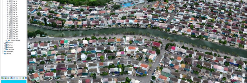
3D point cloud of Fairview Park (錦繡花園) generated by SV-VS (Vision System)

by starvisionPosted on March 11, 2020September 21, 2020Comments are Disabled

Star Vision’s SV-VS (Vision System) created a 3D point cloud model of Fairview Park (錦繡花園).  Fairview Park is a low-rise residential estate area in Hong Kong. SV-VS can also generate orthophoto and 3D mesh model for BIM application.

Copyright © 2025 StarVision Ltd Inspiro Theme by WPZOOM
Show Buttons
Hide Buttons
error: Content is protected !!