Star Vision Ltd. has more than 30 years in satellite image analysis. One of the services is to detect ground subsidence by satellite image. The service is to use satellite image to analyze the shifting or movement of ground surface using high accuracy (at mm level) and high frequency detection method.
Star Vision Ltd. promotes RADARSAT and USGS satellite technology. The following is an example data image processed by USGS, showing the amount of ground displacement by colour.
星眺有限公司在衛星影像分析領域擁有超過30年的經驗。其服務之一是利用衛星影像檢測地面沉降。本服務採用高精度(毫米級)和高頻率的偵測方法,並利用衛星影像分析地表位移或移動情況。
星眺有限公司推廣使用RADARSAT和美國地質調查局(USGS)的衛星技術。以下是由USGS處理的範例資料影像,以顏色區分地面位移量。
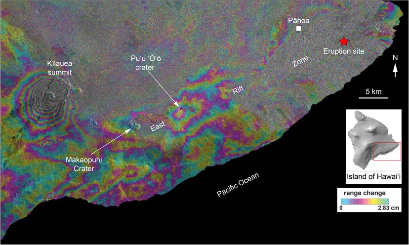
Copyright: Contains modified Copernicus Sentinel data (2018), processed by USGS
2018年5月7日至13日夏威夷島地面位移資料。數據來自Sentinel-1A衛星。
版權聲明:包含經美國地質調查局(USGS)處理的哥白尼哨兵計畫資料(2018年)。
Please feel free to contact us to discuss your interested area(s) and your requirement(s).
請隨時與我們聯繫,討論您感興趣的領域和您的需求。

