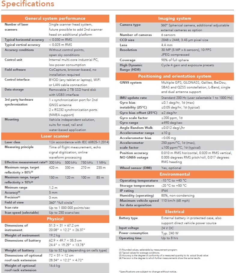
Specifications
1. General system
- Control unit: internal multi-core industrial PC, low power consumption
- Field software: CoCapture, browser-based, no installation required
- Control interface: any tablet or laptop, WiFi or LAN cable connection
- Data storage: removable 2 TB SSD hard disk with USB3 interface
2. Laser scanner
- Brand: Riegl VUX-1HA
- Number of laser scanners: 2
- Laser class: 1 (in accordance with IEC 60825-1:2014)
- Typical horizontal accuracy: < 0.003 m RMS
- Typical vertical accuracy: < 0.025 m RMS
- Effective measurement rate: 300 kHz – 1 MHz
- Maximum measurement range: 85 m – 420 m
- Scan rate: up to 1,000,000 points/sec
- Scan speed (selectable): up to 250 scans/sec
3. Imaging system
- Brand: Ladybug 5+
- Camera type: 360° spherical camera, additional adjustable external cameras as option
- Number of cameras: 6 sensors
4. Positioning and orientation system
- GNSS system: Multiple GPS, GLONASS, Galileo, BeiDou, SBAS and QZSS constellation, L-Band, single and dual antenna support
- IMU update rate: standard 200Hz (user selectable 1 to 1000 Hz)
- Wheel sensor (DMI): Yes, optional
5. Electrical
- Battery type: External battery in protected case, also support direct vehicle power source
- Operating time: Up to 8 hours
Keywords: Mobile Mapping System, Point Cloud, Laser Scanner, Panoramic Image, Spherical Camera, Vehicle, GNSS, IMU

